Friday 17 August 2018

Underground utility location equipment

Locating water lines and cables and other underground utilities is done using a number of equipment, which are essentially of two types, namely magnetic locators and pipe/cable location equipment.
Magnetic locators
Magnetic locators are used to locate anything that can stick or attract to a magnet and hence their name, and are basically used to locate a single point such as a property corner pin made of rebar or water pipe. In utility survey or topographic survey, most surveyors use them to locate property corners or "pins" made of rebar and pipe. These locators can also be used to locate cast iron valve and meter boxes and ductile iron water pipe and underground storage tanks.
Military also does use these when looking for unexploded ordinance. However, the equipment is not a metal detector but specifically for detecting objects with iron/steel (ferrous) content. Otherwise, it does ignore all other kinds of metals including aluminum, copper, brass, coins and precious metals like gold.
These locators are used to detect electric lines, water lines, isolated ferrous (iron/steel) object such as steel property pin, steel manhole cover, steel water or gas valve. However, they are not to be preferred for locating buried utility detection since a pipe & cable locator is most appropriate for such an application.
The depth to which it is capable of locating an object buried in the ground depends on the size of the objective, orientation and mass of the objective. For instance, it can locate a large steel object such as a 55-gallon drum at 15 feet deep.
Cable locators
Cable locators are the second type of equipment used in utility survey and topographic survey classified as either transmitters or receivers. Transmitters induce a signal onto a pipe or cable then the wand or receiver locates the signal the line is producing. The detector will be able to find electric, cable TV, telephone, water or gas pipelines and tracer wire and any buried utility of metallic construction, is linear, buried underground and preferably grounded to the earth along the path or end points.
This kind of detector does not locate plastic or any non-metal utility. For the locator to do the work of locating it by the signal transmitting down, the utility must gave a metallic linear property. However, it can also be able to locate a non-metallic utility when there is a tracer wire buried alongside or included with the utility. In some cases, devices such as plumbers snake or electrical fish-tapes are inserted in the non-metal pipe and located by using this device.
For surveyors working in a urban center where there are many utilities buried underground, the best choice of device to use is a multi-frequency mode pipe and cable locator. It will be possible to isolate each utility from the others and reduce interference, simply by selecting frequencies and power adjustments. A pipe and cable locator comes basically with a transmitter, a receiver; ground stake and conductive (direct-connect) clips that are used to transmit the signal. While the pipe and cable locator can locate power lines without using the transmitter through a method called Passive or 60Hz locating, locating is not fool-proof and is not the preferred method by the Dig-Safe or 811 society.
It is required that the power line is energized and has a significant load to be able to detect the presence of 60Hz. Again, other buried utilities such as gas pipeline, telecommunications cables and event water and sewer lines can have the ability of carrying the 60Hz signal onto them indirectly.
Thursday 19 July 2018

Implementing Fundamentals of Site Engineering For Best Results


All the participants- individuals, engineers, workers, and contractors require various skills and knowledge, for completion of a site development project. Individuals or firms that ensure timely execution of the job at hand carry out site engineering services. Such construction site engineering requires responsible administration and quality control of the construction work, right from the initial stages of designing until completion. Planning, organizing, and monitoring of the technical components are the fundamentals of site engineering for the developmental task.
Most of the professional civil engineering firms, act as the on-site engineer for construction projects.
Setting Out Engineer in London:
Setting out Engineer or the Site Engineers, supervise the development site while performing the duties of a manager at the construction site. They not only locate the site but are also the source of all technical information and decisions regarding quality control on behalf of the entire construction team.
Duties and responsibilities of a Setting Out Engineer:
Setting Out Engineers follow the construction plan to make sure that the development project is built accordingly. They locate, plan and handle the execution of the projects.
  • All the technical documentation of the development project is responsibly recorded and maintained by them.
  • Implementation and maintenance of safety standards on site
  • Submittals, RFI's, Shop drawings and other such information is to be processed by them daily
  • Reporting to Consultants and Owners with work details and site progress
  • Co-ordination with contractors and sub-contractors
  • Site inspections are to be conducted by them while also imparting technical advice and on-site decisions.
  • To undertake surveys and ensure that the estimated budget and deadlines for the project are met while purchasing and negotiating for supplies and materials required
  • Creating site schedule and planning site activities while ensuring proper interpretation and implementation of construction designs
Site engineering thus play a significant role in the implementation of construction projects. Property owners and investors need to hire site-engineering services before any development task as a solution for the proper management of their construction project. It guarantees efficient utilization of investments and production of perfect work quality.

Tuesday 19 June 2018

3D LASER SCANNING

There is no doubt that we live in an increasingly digital world. This is evident in the field of surveying. Where these new technologies are giving engineers an opportunity to carry out their endeavor in a digital format.
Today the traditional scanning process has also advanced along with the advancement made in all the spheres of technology. Now most engineering, industrial units or process use the 3-dimensional scanning services (or 3D Scanning) for obtaining different types of data through different ways and means.

3D laser scanning services has only recently made its entry in the technical, engineering, industrial and other spheres of modern technology. Today most customers require that the data obtained through 3D scan be post processed for obtaining better results, though most are satisfied with the general data obtained.

In undertaking the scanning process there are no set rules for its use, because the data obtained by this process greatly benefits us and is also useful in most cases. The principal characteristic of 3D laser scanning services are as follows: obtaining high resolution 3D surface information of any physical part or object. These lasers scanners can effectively and accurately capture the parts of various shapes, sizes and the material within a fraction of the time. This results in detailed inspection productivity and accuracy of the process.

Additionally, the use of 3D laser scanning helps you to save a lot of your precious time and money. It is worth noting that surveys done with the help of the 3D laser scanners can collect up to millions of data readings within a short period of time. This is accomplished without interfering with the accuracy of the figures or with the efficiency of the work process.

This makes 3D laser scanning most suited technique when it comes to land surveying. Moreover, the use of 3D laser scanning has made it possible to obtain a many point across the entire geometrical figure of the scanned object. This enables the investigator to accurately describe the free form surfaces as well as digitalize it completely. The surface information obtained is used for making part of CAD inspection or for reverse engineering the CAD models from the original physical objects.

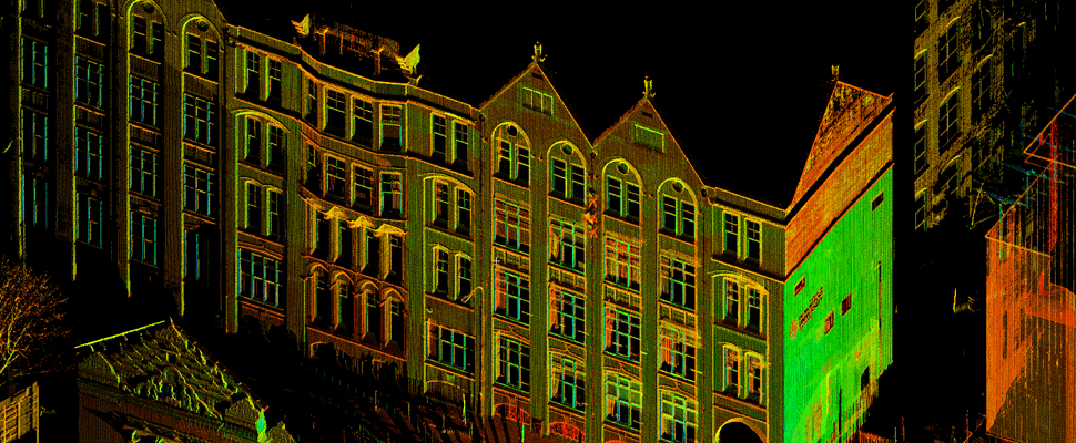
Are you looking for 3D laser scanning services? Then, Datum site services is a highly experienced site engineering services company who are dedicated to provide you with the best 3D laser scanning services. Datum 3D laser scanning systems is consisting of a portable 3D laser scanner which supports standard surveying procedures like instrument setup over a known point, height-of-instrument measurement and instrument orientation. Additionally, any exposed building surface can be remotely captured in minutes to form a dense and accurate 3D point cloud.
Datum site services company carry out all this work within a span of time. In addition, Datum ensure that the work they do is transparent and they have skilled surveyors who are thoroughly proficient at using millions of recorded and surveyed points to produce 2D diagrams and 3D models depending with the client’s requirements. This ensures that you get the best results from their 3D laser scanning services.

Friday 16 March 2018

How Is GPS Surveying Beneficial?

One of the main questions that arise is that whether the 3D Laser Scanning finds any use on the golf course or not. In our opinion, it does have a use. Most of the golf courses appear to have extremely limited information regarding the dimension of their existing topographical structure.
To make things worse, they do not even possess or have scanty information of the original documentation of the course design of the architect. Now, this might seem to be quite petty, but it is not. This is important because the conditions of the course keep on changing with the course of time.
Maintaining the course periodically can settle the important green contours. This is rarely documented properly. Capturing the topography of the course has a lot of benefits to offer. Firstly, a required archive of that golf course is provided. Recording it digitally helps to enable the operations such as cutting and filling for the purpose of remediation and construction. Nowadays, the tools are becoming easier for surveying.
Such an approach will be attractive to the constructors and architects of a golf course. The architects will be enthusiastic to embrace 3D Laser Scanning since it makes “high-fidelity realisation” possible for the designs.
The GPS Surveying Techniques Have Made a Big Impression in This Field
One can now check the distance displayed on the golf cart. Basically, the receivers of the GPS which are used for surveying are quite expensive and more complex than the ones which are used in the day to day lives. The baseline of the GPS makes use of two GPS receivers which are of survey-quality. One of them is fitted on either side of the line which is to be measured. The collection of data is done from the GPS satellites. This collection is carried out at the same time.

This kind of construction surveying is also known as GPS setting out. Generally, the surveys of these courses are performed in accordance with the geodesic coordinates. For the purpose of construction, a coordinate system that is best suited to that condition is used. 
During the time when the construction surveying or the GPS setting out is carried out, the surveyor might have to convert the coordinate system that is most suited for that project from the geodesic coordinates. During linear infrastructure or during construction of roads, a chain age is generally established. The structures are then located in terms of elevation, offset and chain age.
Some other applications of GPS Surveying can be made into fall in these five broad categories.
First is to determine the location or the position.
Secondly, it is used for finding one’s way from one’s source place to the destination, also known as navigation.
Third, it is used for the purpose of tracking that is monitoring the personal movement or an object.
Fourth, it is used to create maps of the world, also known as mapping.
Lastly, it is used for making the timings accurate across the world, which is also known as timing. Thus, GPS can be quite useful in our modern lives.

Monday 26 February 2018

Land Surveying and Site Engineering Services

It is often difficult to find good land surveyors and site engineers while handling construction projects on a large scale. There are some good engineering companies in London with skilled engineers. Their expertise is essential for scanning and surveying the land before the construction. The accurate data surveyed is useful in making some informed decisions which save time and cost of the materials.
The presence of underground cables, voids, and any pipes can be detected using 3D laser scanning. The site engineers can determine the composition of the material underground and its characteristics to check if it is appropriate as a construction site. Site engineer London can take care of construction surveying, 3D laser scanning, and dilapidation surveying. They set the basic foundations for building projects. The accuracy of the construction should be in lieu of the actual drawings made by the engineer to obtain the best outcome.
Role of Site engineer
Site engineering services are crucial to every land survey project and construction companies. Experienced engineers with apt skills and talent will only lead the project to success. A site engineer is responsible for the technical, organizational and supervisory work in a construction project. The location of the project, above and below ground installations, designs and plans have to be carefully inspected by the site engineer before proceeding with the actual construction.
Furthermore, the responsibility of the site engineer includes safety of the site, materials and human resources. The ongoing work and materials used should be in the prescribed standards and the site engineer has to put forward the cost-effective solutions required for the project. The site engineer is an integral part of construction companies, surveying companies, civil engineering companies and for public sector organizations.

The companies related to engineering construction need a site engineer both on-site and off-site. The construction engineering services indulge in both surveying of pre-constructed buildings and lad for new projects. Clients can choose a professional firm which can offer tailor-made designs and services suitable to their needs. The engineering and surveying services have grown popular all over the world with help of latest technologies.

Monday 23 October 2017

Quality Basics of 3D Laser Scanning

3D laser scanning is an advanced technique that can help you collect millions of valuable data in a very short time without compromising on work efficiency and accuracy of figures. Thus, 3D laser scanners qualify as a high-definition system for surveying lands and help to save your money and time.

                             3d-laserscanning

3D Laser Scanning and Its Usage:

3D laser scanning technology helps to gain survey information as well as assists with the construction and design of buildings. High-speed 3D scanners provide life-like images of a required field of work which helps in making well-informed layouts and calculations. 

 It is used in architecture to superimpose an image with accurate specifications on a landscape to know how the finished project would look like. Other industries where it is used are bridge design, aviation, wastewater plants, transportation, and logistics. 

 Advantages of 3D Laser Scanning in Land Surveying: Laser scanners are the most valuable tools used in land surveying. It not only helps to find the issues but also improves their project outcomes and data collection. Here’s how: 

1.Adaptability: 3D laser scanners come in an array of various types and platforms, which allows land surveyors to pick the right tool in accordance with their specific job. Be it mobile laser scanning or aerial mapping, different techniques mean different solutions for land surveying professionals.

 2.Accurate Data Collection: Since laser scanners have the ability to thoroughly assess spaces, the resulting data collection can be used for creating maps with the help of the latest software. Highly precise models and realistic drawings are some of its key benefits since surveyors use them to showcase the solutions to their clients. 

3. Fewer Labour: As it is, there is a shortage of land surveyors. Since laser scanners allow surveyors to take on several projects at once without an overload of work, it helps to reduce the hindrances caused by a labor shortage. The speed and accuracy of 3D laser scanning allow professionals to be more productive as they have to spend a minimal amount of time on each project. It also ensures fewer site visits and reduced rework. 

3D laser scanning is a cost-effective, time-saving technique that involves lower overall risk. It helps land surveyors have access to higher precision data and take on a more consultative role with clients.  

Tuesday 27 June 2017

3D Laser Scanning and Surveying

3D laser scanning is very helpful in surveying and can yield faster, more perfect results than other methods. It can be used for getting accurate measurements for complex objects and buildings, both in outdoor and indoor projects.

3D laser scanning methods are used by setting out engineers at sites. The selection of the equipment will depend on your project and environments, and the setting out engineer should be able to assist. Various equipment are capable of handling various challenges, including narrow job sites, dusty or humid areas, in rain or direct sunlight applications. However, most importantly is the ability to capture detailed data at the target distance.

Modern equipment used have cameras and intuitive touch screens that deliver extraordinary user-experience. For instance, they have large cameras that capture details while providing natural color overlay to scan data in extreme lighting conditions. The touchscreen is large in size and offers clarity, while allowing quick input.

If you are looking for a 3D laser scanning equipment, it is important to check for the one that is light in weight, small in size and with a longer battery run-time per charge, if the target is an outdoor project. These equipment also have differing scanning ranges. For instance, you can get portable devices that can scan up to 150 m.

A scanning device should be built in such a manner that it is not affected by dirt, dust, rain and fog among other intrusions, when you go for outdoor projects. With some devices used by setting out engineers, you can connect to other accessories. For indoor applications, you can get devices used by setting out engineers that can perform over 70 m and these are also ideal for small area applications.         

Many modern equipment also capture and store data for future analysis and reference. You should also go for equipment that can perform in bright sunlight and one that can do remote scanning. Some do have data sharing capabilities.

Instead of purchasing the equipment, you can hire a qualified and experienced setting out engineer to perform the scanning operation, in case you only need the service only a few times after a long time. It is important to look for someone with experience in using this method under varying conditions and challenges.